The Maps may be Missing, but We are Still Here
International cooperation in mapping is important, but who is really leading?
How should you map seas of islands in the Pacific? The region, like others in the world, is threatened by disasters and the climate crisis, and mapping can help in responding to such major issues. But first, listen. There is a popular saying across the ocean, from Pilipinas to Aotearoa: If you want to reach your destination, then remember where you came from.
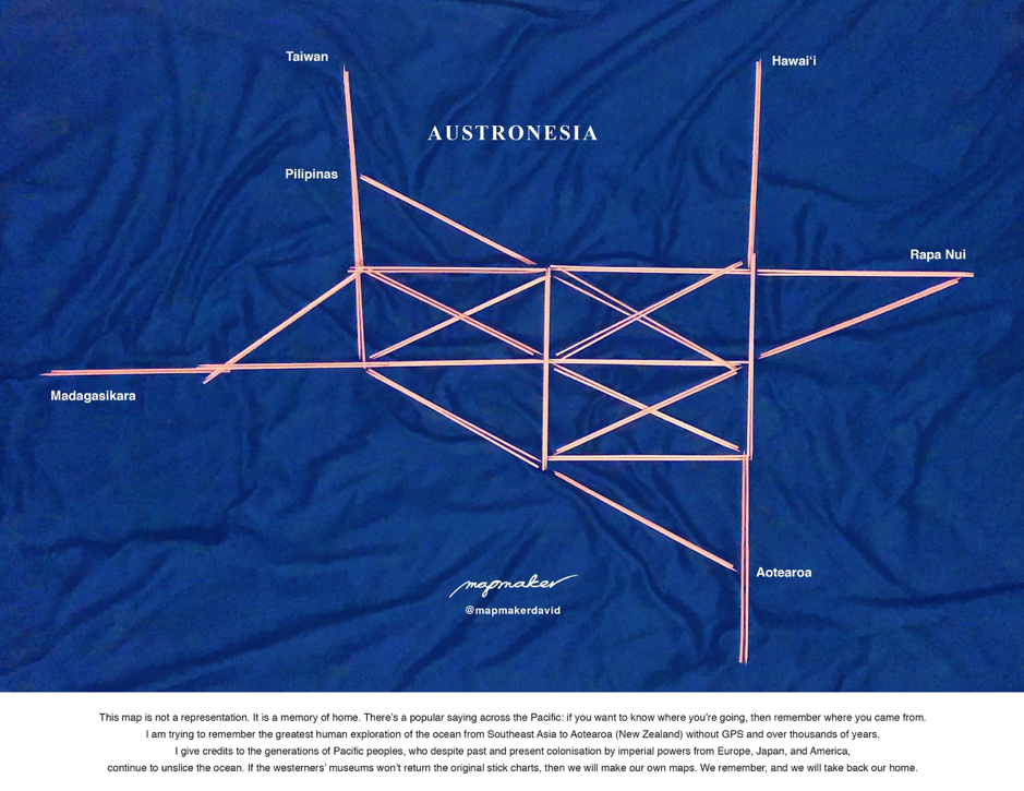
As humanitarian mapping and other major geospatial projects continue in Moana Oceania, also known as the Pacific, it should be remembered that we the people who are born and raised in this ocean and its islands are descendants of the greatest navigators, the Austronesians. I am of the Kapampangan and Tagalog peoples who descend from Luzon Island, which is part of the seas of islands of Pilipinas (the Philippines). The map below depicts a migration of my ancestors and their relatives from Taiwan to the regions of Madagasikara (Madagascar), Aotearoa (New Zealand), and beyond. They accomplished this by observing the waves, winds, stars, birds, and many other signs; inventing seafaring technologies; and taking care of communities along the way. They were mapmakers, from whom western colonisers borrowed expertise during the colonisation of the ocean, which continues today.
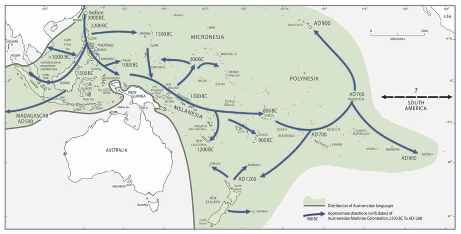
Figure 1. The Austronesian migration credit
Hence before you proceed, please be aware that my way of reasoning and aspiring may seem tautological and mundane. But the reader must recognise that I descend from and tap into an oceanic wayfinding culture that regards spacetime as cyclical, recursive, and highly relational. This means that the past is in front of us while the future is behind us in an ever-living present. In international buzzwords, it is called “iteration” and “networking”. This also means that I draw from an intergenerational body of geographic knowledge that is not limited by shapefiles or map tiles. For example, our relatives in what was called Micronesia, which is in fact a group of large ocean states, have been making maps about the relationships between seas of islands for a very long time.
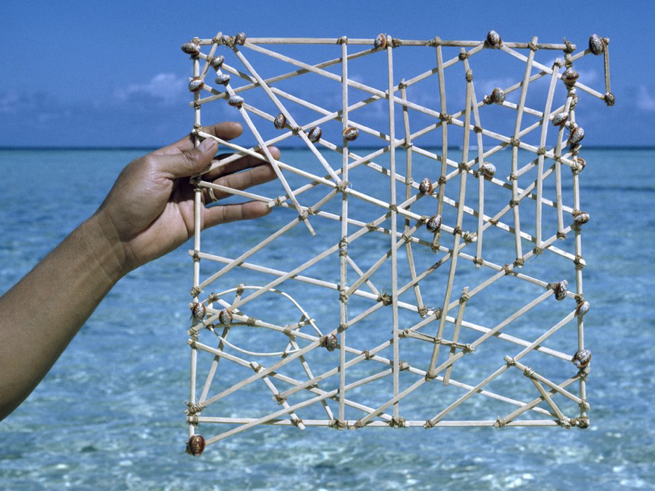
Figure 2. An ocean chart by Indigenous wayfinders of Micronesia credit
We know where we are going because we know where we came from. This means that our intergenerational geographical knowledges are with us and should be respected, while we have been under threat by colonialism, imperialism, capitalism, patriarchy, and many other systems of oppression for hundreds of years.
If you look at history and geography with a deep sense of time and space, then you will know this important truth: we are not missing from the maps. In fact, we have been overmapped. For hundreds of years, Western cartographers and ethnographers have been profiling our interrelated peoples, absurdly slicing the ocean, and concocting controversial racial hierarchies and questionable regional categories. These problematic patterns persist until today, whether in outputs or organisations who do the mapping and storytelling. Mapping has been very troublesome. And while maps may be missing from digital platforms and social networks, we are still here.
Figure 3. A racialised and segregated 1832 map of Oceania, made by the cartographer, explorer, and coloniser Dumont d’Urville
“First, do no harm”, say many manuals in the humanitarian sector. Truth be told, cartography and geospatial technologies, which are intertwined with colonial projects, have been harmful and traumatic for the vast majority of the peoples of the world. The extractive methods of producing geographic knowledge are a core part of the painful construction of international systems that belittle, misunderstand, disrespect, and exploit us peoples of the ocean and our other living relatives. For example, the US military, as it was mapping the Philippines, hosted the largest overseas US military base in our town and left toxic waste that has been making the children suffer. The experience has been the same across the Pacific. This trend towards extinction continues today, as colonial powers remain present in many seas of islands such as Guåhan, Ryukyu, West Papua, Australia, Kanaky, Hawaiʻi, Tahiti, Aotearoa. The list goes on. Hence, remember that the context of our mapping is that we do not live in a postcolonial age; instead, we are inside a recolonising milieu. Remember that colonialism is an ongoing disaster, and we must confront it, too, to alleviate suffering, uphold human rights, and redefine development.
“Maps have done a lot to confuse things for people. And I think more lands have been lost to native peoples probably through mapping than through physical conflict.” Jim Enote, Zuni Nation
How can we avoid such harms in the production of geospatial knowledge, especially in large geospatial projects? First, there must be opportunities and safeguards for the refusal of mapping. Another top priority is to revisit the ethos, including humanitarian ones, that we enunciate and internalise during our mapping. Next, we must critically support mapping projects led by Indigenous organisations. While we do this we must work with and follow organisations that respect Indigenous peoples and Indigenous sovereignty.
Last year, we hosted a mapathon here in Aotearoa, also known as New Zealand, for mapping seas of islands here in our ocean. The event, organised with the support of FOSS4G-SotM Oceania 2019, was attended by folks of various backgrounds across the large ocean states. We were making maps for, with, and by the Pacific. I acknowledge the Indigenous peoples of Aotearoa for the space and opportunity to do this work, while I follow their leadership in the journey towards the full decolonisation of New Zealand and the rest of the Pacific.
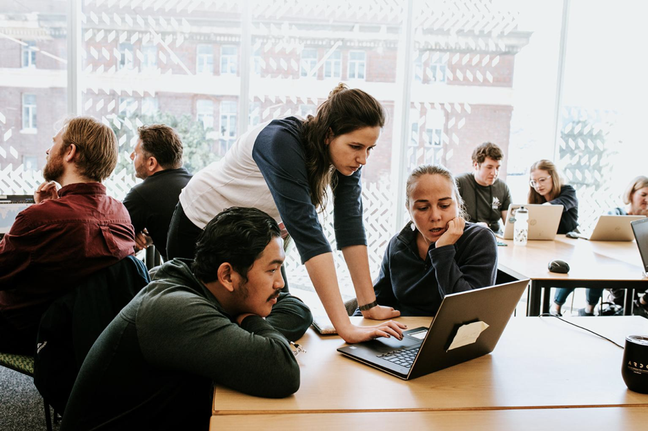
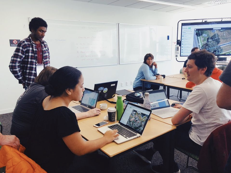
Figure 4 and 5. Participants in the Missing Maps mapathon in Wellington, Aotearoa (New Zealand) last November 2019. Photos by conference organisers
Remember that the job of the mapmaker is not just to produce visuals or provide data. Through the peoples and places they make maps with, a mapmaker creates meaning that weaves together space, knowledge, and power. Now, what will that meaning be? Will it just be about a reproduction of colonial, imperial, extractive, and patriarchal projects that devalue, traumatise, and annihilate life? Or will it help in the emancipation of marginalised peoples, abolition of oppressive structures, and regeneration of Indigenous power? If you are a mapmaker, then ask yourself, “who are you making maps for?” and “who are you making maps with?” More importantly, who is leading your mapping?
As international geospatial projects continue, I strongly hope that more spaces are created for the leadership of Indigenous peoples in Indigenous-led geospatial organisations. In this transition that is already happening, it is necessary to frame mapping not just in terms of representation, but also of power. It is not just the maps that matters. Who makes the maps matters. Who tells the stories of the mapping matters, too. Who leads the mapping and storytelling also matters. Who gets powerful due to the mapping and storytelling matters most.
For many years, I have been participating in and organising mapping hackathons, meetups, and many other mapping projects in the Philippines, UK, Aotearoa (New Zealand), etc. With other volunteers like you, I have been giving my labour, time, expertise, stories, and so much more. Like you, I take mapping seriously. And like my ancestors, we the children of this ocean and its islands are mapmakers. But we are not your laboratory, pilot project, best practice, report cover, click farm, or geospatial dot. In fact, international organisations need us the natives and our Indigenous relatives more than we need them.
How should you map seas of islands in the Pacific? If you are helping us do that, then please remember that you are not our saviours. You are not here to save us. Instead, you are here to contribute to our survival and success, which we have already been doing, and support the reclamation of our sovereignty as peoples of this ocean. The work for social and spatial justice, including the decolonial, is very messy, uncomfortable, and seemingly endless, but let us do that together, with natives and Indigenous peoples present and leading. There is a popular saying across Moana Oceania Pacific: If you want to reach your destination, then remember where you came from.
The maps may be missing, but we are still here.
– David Garcia (@mapmakerdavid) is a PhD candidate in Geospatial Science. At present, he is supporting the Ministry of Mapping (@mappingministry), a geospatial collective in the Philippines. He loves making maps of his home, the Pacific. And if the ocean is unsettling, then be the ocean.