So far the Missing Maps mappers created a lot of data in terms of quantity, but now we need to focus on more quality. And this quality will come from the local mappers because they are the ones who know the specific places and they are the ones that are able to keep the map up-to-date. For me, as eHealth advisor, from the public health view, locations of health facilities and place names like villages are the most important to map. For others within MSF, like community outreach teams or water and sanitation specialists, it might be rather general points of interests like mosques and schools to know where to go and to meet.
- Raphael Brechard, eHealth advisor Médecins Sans Frontières
Stories from Community Mappers
Many Missing Maps volunteers learn how to contribute to OpenStreetMap (OSM) by remotely mapping communities where they do not live. This type of mapping is a fun way to see how others live while helping communities and NGOs with spatial data and is a great way to be introduced to the OSM platform. However, much of Missing Maps’ remote mapping is limited to building and road features. There is so much else you can map in OpenStreetMap, even in your own backyard!
The highest quality areas of OSM are those that are infused with local information from a diverse group of mappers. Avid OSM-ers have been mapping their own neighbourhoods across the world for years. The best way to collect accurate and up-to-date local information is to get outside and map! Whether it is mapping bus stops, streetlights, water points, local corner shops, street names or recycling bins, the best way to collect data may be by doing a mapping survey by foot, bike, motorbike, snowmobile, or car. Enjoy hiking? Why not combine two hobbies and map a trail that is not yet part of OSM? If you would like to boost your mapping skills, learn more about your community and share your knowledge with others, local community mapping may be for you!
We have collected the stories of several enthusiastic OSM-ers who have mastered the art of mapping their own backyards. They have offered their advice for those who are first starting out and shared the reasons why they have become so passionate about local mapping. Enjoy!
Herry Kasunga, Tanzania
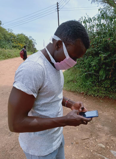
Herry Kasunga mapping his community using the Maps.me application on his Smartphone. This mapping will later support planning activities to help girls who are in vulnerable places (such as those at risk of undergoing female genital mutilation).
Who are you? My name is Herry Kasunga. I am a GIS Analyst in Tanzania and also a community mapper in Serengeti, Mara Region. To make a long story short, I was visiting my family in a small town called Mugumu in 2020. While I was there, I met an enthusiast mapper called Janet Chapman who was mapping our community (Serengeti) to help girls who are in vulnerable environments (e.g. places with gender based violence and female genital mutilation). We spoke about the benefits of mapping our community and how can that help when rescuing girls who are in those vulnerable enviroments. I was inspired by her - mind you, I have cartographic and GIS knowledge - and I started taking an initiation of using my knowledge to map my community with a goal of helping girls who are in vulnerable enviroments. I also started training other community members on how to map and local YouthMappers at the Serengeti Tourism College.
Ideal day mapping? My favourite days of mapping are the days when I run an online training for other local mappers in different locations; mostly in Tanzania. My other favourite times are when I am going to the market or town visiting and training Serengeti YouthMappers. I map building features, linear features and point features (like Hospitals, Dispensaries, Pharmacy, Clinic, Schools, Police Posts Safe Houses) and other important features. I always prepare a questionnaire for data collection based on our community needs, particularly for the Digital Champions run by Hope. I use OpenDataKit (ODK) to collect the necessary information. I also use Maps.me smartphone application, Mapillary, iD Editor and JOSM for mapping and collecting information.
Why map? It’s very important to map our community. The data are used for: planning and help to rescue girls who are in vulnerable environments; helping in making decisions on which approach should we take to solve community challenges such as where should we construct boreholes that would be easy for everyone to access; monitoring and conserving our natural resources; keeping records of our features; and also for research and analysis like land cover and land use change detection.
Advice for new mappers? I would advise people who are looking to get started to learn how to map because by mapping, you are raising the voice of people in your community. Mapping is telling stories about your community and we should all be happy doing this.
Gregory Marler, United Kingdom
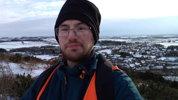
Gregory at the top of a hill overlooking Pittington. This is a village that he attempted to survey all in one go! It was much snowier and colder than he thought he could cope with. The adventure was filmed for his "Mapper Diaries" channel on YouTube, which is a bit like walking alongside Gregory as he goes about his typical mapping.
Who are you? I’m Gregory Marler, and I go by the username “LivingWithDragons” which relates to my early involvement in OpenStreetMap. I saw the potential in a free map of the world and shortly after I moved to a city that was almost blank on the map so I knew I needed to start mapping for others to use it. It was a great way to explore every footpath and road in the small city of Durham in the North East of England.
Ideal day mapping? Fourteen years on and I’m finding different things to add on the map and to make it more detailed. On my smartphone, I use OSMAnd to record tracks and usually take loads of photos. If I’m focusing on house numbers, I’ll use Keypad Mapper. As I’ve got a technical mind, I’m more comfortable using the JOSM editor on the computer in which I open up the GPS track and all the photos. I map things I see and things I see that will be useful. I quite like mapping postboxes and playgrounds because people might not realise where the closest one is. I get updates on the OSM UK quarterly projects as they inspire me to check things are well mapped in my local area and that nothing is missing or wrong.
Why map? I like getting outside and walking and discovering new places. I’ve found many green spaces, great views, or different buildings because I went to map something else. The maps also get used in different and surprising ways, I was able to include litter bins on a map for volunteers in the city centre which was helpful as they dispose of broken glass between helping people on weekend nights. More recently I discovered a “public bookcase” in my neighbourhood and was able to direct others to the small facility while libraries have been closed.
Advice for new mappers? Get used to exploring OpenStreetMap in similar areas to where you live, look at the data and the categories of different objects. Often you will learn new categories that way and you might spot the features when you are out and around your own area. I didn’t know how to map public bookcases but I knew others had mapped them, so I looked it up on the OSM Wiki and found out there’s lots of details I could record. I was surprised it even displays on the main map style, but I can also see how many exist(that have been mapped) in the UK and the world.
Matthew Darwin, Canada
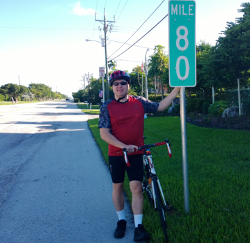
Matthew on a bike trip in the Florida keys. He biked from mile marker 80 all the way to 0!
Who are you? I’m a computer software developer/manager in Ottawa. I have no background in GIS but find it interesting. I like being involved in civic building projects (I previously served on the community association,volunteered with Big Brothers, etc.). I like to keep busy! OSM was discussed at the Ottawa CivicTech meetup. I thought it sounded interesting, so I joined an “Intro to OSM” Meetup. I started mapping in JOSM right away. I had a bunch of time as I was in-between jobs.
Ideal day mapping? Ottawa is now fairly well mapped due to a lot of great City of Ottawa open data as well as a huge volunteer effort. So work is mostly about completing missing areas. When I started, there were lots of messy things which I spent many months helping to clean up. I spent a lot of time on street naming. Effort is put into active transportation infrastructure such as paths, bike parking, water fountains as well as addresses for new or updated areas of the city. I spend most of my time mapping in the car or on a bike taking photos for Mapillary. The tools I use include: JOSM, Mapillary, Keypad Mapper and Field Papers. I spend a lot of time doing quality assurance on OSM data across Canada - things you can improve without detailed local knowledge such as fixing the formatting of phone numbers, postal codes or fixing the spelling of cities and street names.
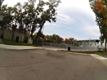
A photo Matthew took last fall from a camera attached to his bike and uploaded to Mapillary. It is a photo of the new bridge that replaced the bridge he used to go over every day on his way to high school (bike or walking).
Why map? Most importantly, to have an open database of things that can be used in other local projects. I don’t want to have to pay for commercial maps. It’s about “freedom”. I live in Canada’s National Capital which is an area made up of 2 cities in 2 provinces, with some parts owned by the federal government. There is no open dataset that covers everything. I need to use OSM to gather all the open data from 3 sources into one common place. You can directly influence the map for places where you go. Whenever I travel, I try to use OSM as much as possible.
Advice for new mappers? Work on mapping things you enjoy or you know someone will use or ideally, both.
Leigh Lunas, Philippines
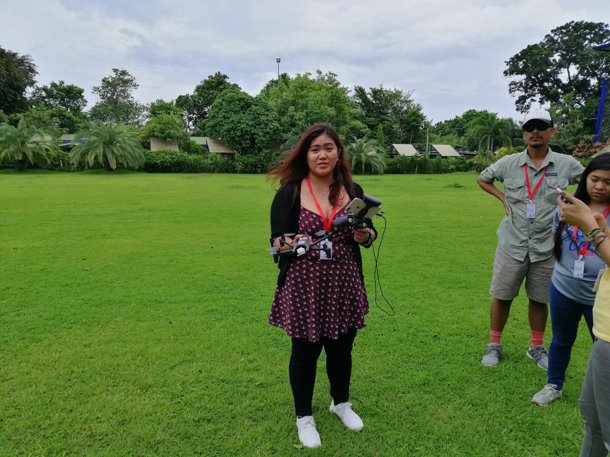
Leigh showing mapping enthusiasts how to use drone for aerial surveying at Pista ng Mapa in Dumaguete in 2019.
Who are you? Henlo! I’m Leigh Lunas from Geoladies PH. I started contributing to OSM during my work assignment in Cebu back in 2013. I was looking for a coffee shop near my place and I couldn’t find any on the map. I walked around the city and found one and immediately I added it on OSM. I felt great putting that kind of information for other people from the community to help them too. From there, I started adding more places from shops, restaurants to trails, roads, building footprints, breastfeeding facilities, LGBT-friendly spaces, and many more!
Ideal day mapping? I usually just join OSM PH-hosted mapathons for post-disaster operations, vulnerable places, schools, violence against women and children centers, mental health facilities, and others using iD Editor and JOSM. For mapping trails, I use my watch to record my track and upload to OSM. For on-the-go mapping, I use Maps.me or Go Map!! using my phone and add categories like store hours, gender-neutral toilets, baby changing rooms, etc. In 2019, I get to map an urban community by using a drone to provide higher resolution imagery for digitizing in Lupang Arenda in coordination with the barangay officials, OSM PH, and drone volunteers.
Why map? Spatial information is powerful. It can improve the lives of people and collectively, can be used for science or even art! For me, I do it because I enjoy contributing in my own geeky way to my community and sharing my discoveries of new places and trails.
Advice for new mappers? You can start small. Incorporate it slowly in your daily life, if you commute to work/school, you can validate the places you frequently visit, if you like to run or hike, use your phone to track your trail. Due to pandemic, join OSM PH online map-athon events! This is where you will meet like-minded people and find out what inspires you to continue mapping. Don’t let the number of OSM contributions overwhelm you and keep you from mapping. Map how and whenever you can.
I have met amazing map-py geeks that are truly inspiring in OSM PH community events! It gets easier to get into it if you surround yourself with genuine and supportive people.